
Supporting Information
The IUCN Red List is more than just a list of species names and Red List Categories. It is a compendium of information detailing the current extinction risk for the animal, fungus and plant species that have been assessed to date.
In 2000, IUCN compiled all Red List assessments from the 1996 IUCN Red List of Threatened Animals and The World List of Threatened Trees into one electronic Red List, which marked the beginning of The IUCN Red List website. At that time, just over 16,500 species were included on the Red List, each one with very basic information attached. In 2004, it became a requirement for Assessors to provide supporting information for all submitted assessments. Currently, The IUCN Red List includes assessments for over 157,100 species, most of them documented with information supporting their Red List status.
The minimum and recommended supporting information requirements for assessments being submitted for publication on The IUCN Red List, and guidance on what information to include in a Red List assessment, are available in the Supporting Information Guidelines.
Red List assessments are available as online assessments (or fact sheets), and also as PDF publications that can be downloaded from the fact sheets. Both versions provide three general types of supporting information:
-
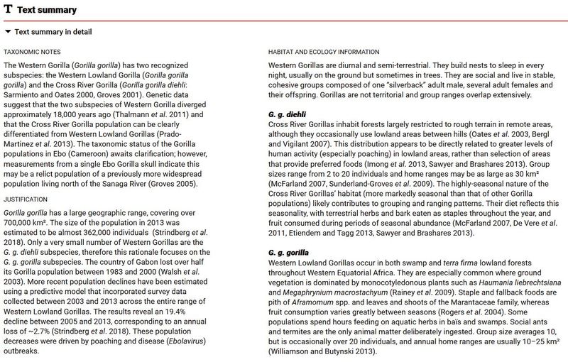 Text – each assessment includes text describing the reasons for placing the taxon into a particular category, its global distribution, and what is currently known about its population, the habitats it relies on, threats, use and trade, and conservation measures. The text justifies the placement of the taxon in a particular category and the context for conservation action.
 -
 Data – all assessments include coded information (Red List Category, Red List Criteria, countries of occurrence, threats, habitats, conservation and research actions, etc.). Many assessments also include data (population size, generation length, number of locations, etc.). These data contribute to justifying the placement of the taxon in a particular category, but they also allow the Red List to be analysed and for users to perform a wide range of searches on the website.
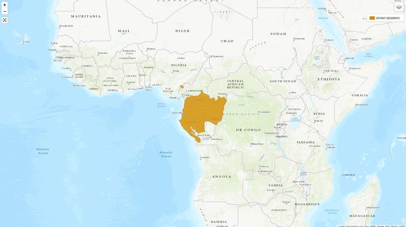
-
Distribution map – most assessments include a distribution map. The map provides a quick illustration of where the species occurs, and the underlying spatial data are also used for analyses.
The PDF version of an assessment includes the same text, data and map that is displayed in the fact sheet, except for images of the taxon and data from external sources. For some taxa, the PDF version displays a different scientific name from the one used in the fact sheet (see Taxonomic Revisions on The Red List for an explanation).
Note that data that are not part of the minimum supporting information requirements may not be recorded for all taxa on The IUCN Red List.
Within each Red List assessment, supporting information is displayed in different sections, which include both text and data (there is also a Text Summary section that shows all of the assessment text in one place). The different sections of the assessment are explained in more detail below.
Assessment Summary
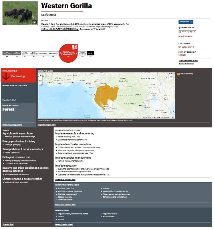 The first section displayed on the fact sheet is an assessment summary. This provides a quick guide to the taxon’s status, where it is found, what threats are affecting it, and what conservation actions are in place or recommended.
The following information is included in the assessment summary:
-
Any available photographs or other images of the taxon are displayed at the top of the fact sheet. Note that the PDF version of the assessment does not include any images of the taxon.
-
The primary common name is shown at the top of the fact sheet; where there are no common names recorded, the scientific name appears instead.
-
For taxa that have a common name displayed, the scientific name appears below this.
-
The assessment citation is clearly displayed beneath the scientific name. For more information about citing assessments and other information from the website, see Citing The IUCN Red List.
-
The assessment summary includes a download tool, where a range of files can be downloaded, including the PDF version of the assessment, any supplementary information, spatial data, and an image of the distribution map. Note that not all assessments have supplementary information or maps (see Distribution Map and Supplementary Information).
-
A Google Translate option is provided to allow users to view assessments in different languages.
-
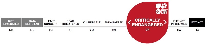
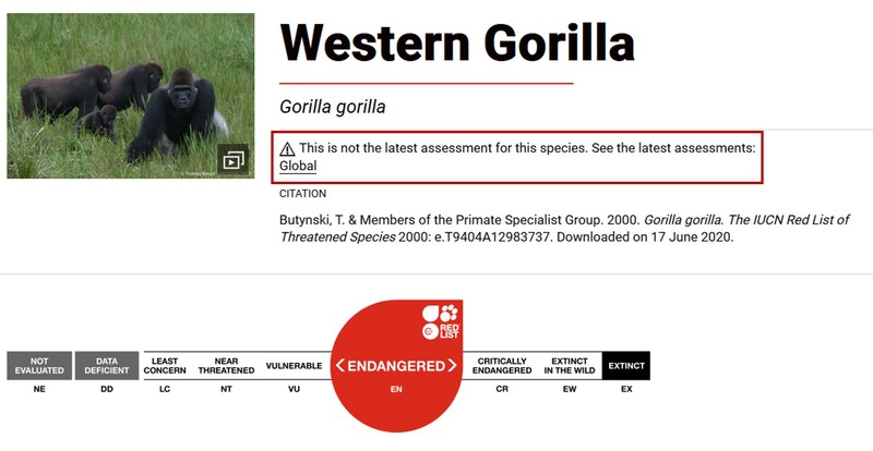
The Red List Category the taxon is listed under is displayed in the Red List scale image. For example:
-
The date the taxon was last assessed is the current assessment date.
-
The scope of the assessment indicates whether the assessment is for the global population, or if it is a regional assessment (i.e., an assessment of only part of the global population).
-
The remaining assessment summary panels show:
-
Current population trend.
-
Number of mature individuals (i.e., population size) if this information is available.
-
The general habitats used by the taxon.
-
The distribution map (see Distribution Map below).
-
The general threats affecting the species, if any.
-
Conservation actions in place for the taxon.
-
Conservation actions needed to secure its future survival.
-
Research needed.
-
Distribution Map
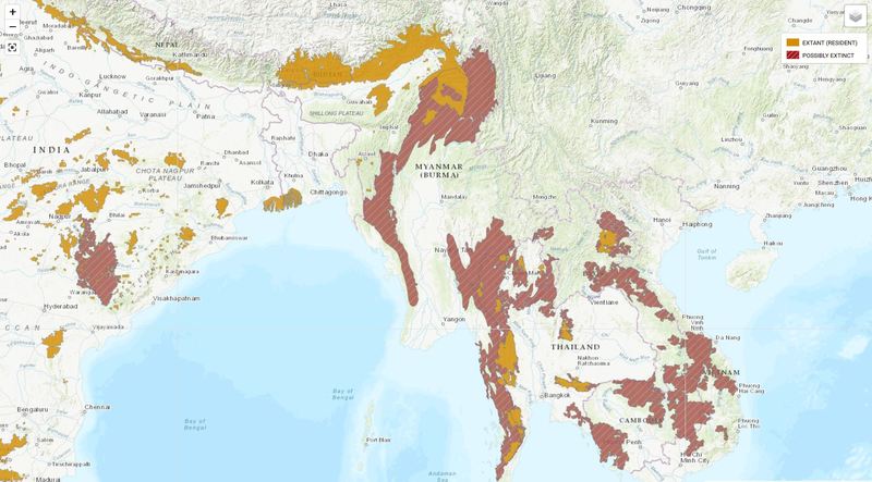 The distribution map is an important piece of supporting information for Red List assessments. It provides a quick reference for where the taxon occurs, and it also provides data that can be combined with other datasets for analyses that inform development of conservation actions, national and international policies, and decisions within the private sector.
The IUCN Red List provides the taxon’s distribution as an interactive online map, an image (jpeg file), and as spatial data (the ArcGIS shapefile and/or the point data csv file can be downloaded). Three map types are available, depending on the taxon: some taxa use polygons to show the limits of their distribution, some taxa display point data maps, and freshwater taxa are mapped to HydroBASINs. Some taxa use a combination of map types to illustrate their distribution (e.g., some dragonflies display both point data and HydroBASIN maps to show the potential limits of their distribution alongside where they have actually been collected).
Some fact sheets do not display a map. This may be because the taxon's distribution is not known and the map is therefore impossible to create, or it may be because the map has been withheld for a specific reason (e.g., the map data were provided for assessment purposes only but IUCN does not have permission to repost the map). For some taxa, their distribution is sensitive; for those taxa, the map will either be withheld from the website, or a generalised map will be displayed (e.g., a map showing entire countries instead of distributions within those countries).
For more information about maps on The IUCN Red List, see the Mapping Standards and Data Quality for IUCN Red List Spatial Data and the Spatial Data & Mapping Resources in the Resources and Publications pages (which include a Spatial Data Download page where spatial data can be dowloaded in bulk ).
Taxonomy
 The main taxonomic focus of The IUCN Red List is on species. However, many assessments have also been carried out for infraranks: subspecies, varieties (for plants only), and subpopulations (or stocks). The rules for assessing infraranks are outlined in section 2.1 of the Guidelines for Using the IUCN Red List Categories and Criteria (also known as the Red List Guidelines).
The following information is included in the Taxonomy section:
-
Higher taxonomy details for Kingdom, Phylum, Class, Order and Family. Note that higher taxonomy infraranks, such as Subfamily, are not shown on The IUCN Red List. The higher taxonomic levels have hyperlinks embedded; by clicking on any level, you will automatically search the Red List website for a list of all species in that kingdom, phylum, class, etc.
-
Scientific name and taxonomic authority.
-
Synonyms, including the original published name (if the name has changed since then), other names that were recently used for the taxon, alternative names that are still in common use, and incorrect spellings that have appeared in past IUCN Red Lists.
-
All common names for the taxon that are recorded (in any language) in the IUCN Species Information Service (SIS) are shown.
-
Taxonomic source(s) provides the references used for the current taxonomic treatment being followed for the taxon. Often this is an online taxonomic database (e.g., for fish species, Eschmeyer’s Catalog of Fishes is the main taxonomic source used), or it may be a publication more specific to the species being assessed (e.g., the original published description, or a more recent publication revising the taxonomy).
-
The Taxonomic notes provide a summary of any recent or ongoing taxonomic debates about the taxon’s validity, any taxonomic changes that are expected to happen in the near future, and sometimes include information about the taxonomic history leading up to the current taxonomic treatment.
-
Infra-specific taxa assessed on the Red List are listed, with hyperlinks to those fact sheets. Fact sheets for infra-specific taxa also include hyperlinks back to species-level fact sheet.
-
Identification information is provided for some taxa and includes information on identifying features of the taxon (size, markings, calls, etc.).
Assessment Information
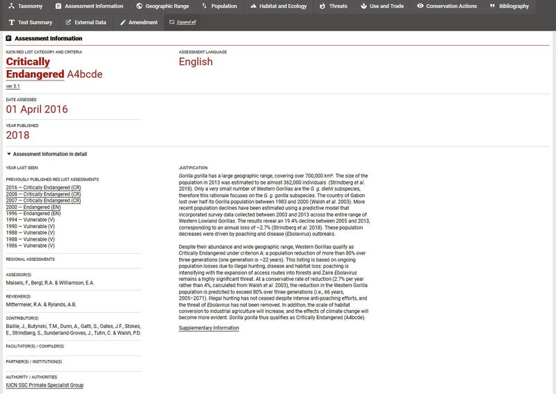 Each fact sheet includes a summary of the information directly related to the Red List Category and Criteria assigned to the taxon. The Assessment Information section includes the following information:
-
The IUCN Red List Category the taxon is listed under. Note that the Red List Category has a hyperlink embedded; by clicking on the category you will automatically search the Red List for a list of all species listed in that category.
-
The Red List Criteria met are displayed for taxa assessed as threatened (i.e., taxa assessed as Critically Endangered (CR), Endangered (EN) or Vulnerable (VU)), and criteria that are nearly met are displayed for Near Threatened (NT) taxa. Note that only the criteria that are met for the highest Red List Category (i.e., the category assigned to the taxon) are shown.
-
The version of the Red List Categories and Criteria used for the assessment. Most assessments published on The IUCN Red List use the IUCN Red List Categories and Criteria. Version 3.1 (IUCN 2001, 2012). However, there are still some taxa that were last assessed in 1996-2000; these assessments used the IUCN Red List Categories and Criteria. Version 2.4 (IUCN 1994). Click here for a summary of the differences between the two versions.
-
The assessment language is highlighted. The IUCN Red List now accepts assessments in English, French, Spanish and Portuguese.
-
Two dates are displayed: the date assessed is the date the assessment was completed, and the year published is the year in which the assessment was published on The IUCN Red List website. These dates may use the same year, or there may be several years between them (e.g., if the assessment is part of a large global assessment project, it may not be submitted to the Red List Unit until all assessments for the project are completed; or a submitted assessment may be returned with comments for the Assessors to address and it may be some time before it is resubmitted).
-
Some fact sheets may have annotations displayed. For example, if the date assessed is more than ten years old, the annotation “Needs updating” is displayed; or if the assessment currently has a petition lodged against it, the annotation “Petitioned” is displayed. For more information about Red List assessment petitions, see the Procedure for Handling of Petitions against Current Listings on The IUCN Red List of Threatened Species™ (Annex 5 of the Rules of Procedure).
-
Year last seen is shown for taxa that are assessed as Extinct (EX), Extinct in the Wild (EW), and for Critically Endangered taxa that are flagged as Possibly Extinct (CR(PE)) or Possibly Extinct in the Wild (CR(PEW)). The “year last seen” is intended to indicate when the taxon was last recorded in the wild (based on sightings, collections, photographic evidence, or some other evidence of live individuals being present at that time). In general, extinction, or possible extinction, is considered to have happened sometime between the “year last seen” and the “date assessed” for the first time the taxon was assessed as EX, EW, CR(PE) or CR(PEW). For more information on how to determine extinction, see the Red List Guidelines and the Extinction assessment tools.
-
If the taxon has been assessed before the current assessment was published, a list of previously published Red List assessments is displayed. All assessments since 2000 include hyperlinks to those historic assessments. If a historic assessment is opened, text appears at the top of the page, highlighting it as an old assessment, with a link to the current assessment provided. For example:
-
Some taxa have both global and regional assessments published on The IUCN Red List (for more information on regional assessments on the Red List, see Featured Regions and Regional Assessments). In these cases, the assessment includes a list of the regional assessments, with hyperlinks to those assessments. Similarly, the regional assessment includes a hyperlink (in the “regional assessments” section) to the global assessment, if there is one, and to any other regional assessments for the taxon.
-
The assessment credits are displayed in the following sections:
-
Assessor(s): These are the people who completed the assessment (i.e., they assigned the Red List Category and Criteria). The Assessors are also the authors of the assessment and their names appear in the assessment citation. For some taxa, an institution (e.g., BirdLife International), Specialist Group (e.g., IUCN SSC Amphibian Specialist Group), or a named Assessment Workshop is recorded as the Assessor.
-
Reviewer(s): These are the people who reviewed and approved the assessment before it was submitted to the IUCN Red List Unit.
-
Contributor(s): These are people who contributed information for the assessment, but they were not directly involved in the assessment. Contributors may not necessarily agree with the final outcome of the Red List assessment.
-
Facilitator(s) / Compiler(s): These are people who led a working group in an assessment workshop (Facilitators) or who researched the available literature and compiled the relevant information for the assessment, usually prior to a Red List assessment workshop (Compilers).
-
Partner(s) / Institution(s): These are the Red List Partners or other institutions that made the assessment possible, usually through provision of funding or overseeing a large assessment project.
-
Authority / Authorities: These are the Red List Authorities (RLA) that are responsible for the taxon. There may be more than one RLA responsible for some taxa.
-
-
All assessments include Assessor(s) and Reviewer(s); inclusion of the other credits varies depending on the taxon and the assessment project.
-
The assessment justification uses information from elsewhere in the assessment to provide a summary of why the taxon is listed in a particular Red List Category, with justification for any criteria used.
Geographic Range
In addition to the Distribution Map, which provides a quick geographic reference for where the species occurs, Red List assessments include more detailed information on the taxon’s range. The Geographic Range section includes the following information:
-
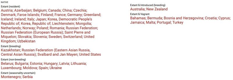
All countries of occurrence, and some sub-country units (states, provinces, etc.), are coded for presence (extant, possibly extant, possibly extinct, extinct post-1500, or presence uncertain), origin (native, reintroduced, introduced, vagrant, origin uncertain, or assisted colonisation) and seasonality (resident, breeding season, non-breeding season, passage, or seasonal occurrence uncertain). These codes are used to display country lists in different groups (native range countries by presence and seasonality, introduced range countries, vagrant range countries, etc.). For a full list of all the countries and regions used in IUCN Red list assessments, click here. For example:
-
For marine species, the FAO Fishing Areas in which the taxon occurs are listed.
-
Upper and lower elevation limits are shown for terrestrial taxa, and upper and lower depth limits are shown for marine and freshwater taxa.
-
The text in the Range description section explains what is currently known about the taxon’s geographic range, including its current distribution and historic range where the taxon no longer occurs (where this information is available).
-
To apply the IUCN Red List Criteria, Assessors must use a range of parameters (see the IUCN Red List Categories and Criteria. Version 3.1 and the Red List Guidelines for definitions and guidance on how to estimate these parameters). Where data are available, they are displayed in the fact sheet. The parameters relating to geographic range are:
-
The number of locations and whether there is any continuing decline or extreme fluctuations in number of locations.
-
Estimated area of occupancy (AOO) and whether there is any continuing decline, or extreme fluctuations in AOO.
-
Estimated extent of occurrence (EOO), and whether there is any continuing decline, or extreme fluctuations in EOO.
-
Population
 Not all taxa have direct information available on actual numbers of individuals, but indirect information can be used to determine whether the population is in a heathy state to ensure the taxon’s continued survival.
The Population section includes the following information:
-
A description of the population, including what is known about population size, trends, and structure (e.g., how many subpopulations there are, degree of fragmentation of the population, etc.).
-
The current population trend is displayed. There are four options for this general description of the population trend at the time of the assessment: increasing, decreasing, stable or unknown. Note that the population trend includes a hyperlink; by clicking on the trend, you will automatically search the Red List website for a list of all species coded with that population trend.
-
To apply the IUCN Red List Criteria, Assessors must use a range of parameters (see the IUCN Red List Categories and Criteria. Version 3.1 and the Red List Guidelines for definitions and guidance on how to estimate these parameters). Where data are available, they are displayed in the fact sheet. The parameters relating to population are:
-
The number of mature individuals (= population size) and whether there is any continuing decline or extreme fluctuations in population size.
-
The number of subpopulations and whether there is any continuing decline, or extreme fluctuations in subpopulations.
-
Where all mature individuals exist within one population only, the section All individuals in one subpopulation will be noted as Yes.
-
Where the number of mature individuals occurring in the largest population has been recorded, this will appear in under No. of individuals in largest subpopulation.
-
Habitat and Ecology
 Habitat loss is a major threat to biodiversity. For an extinction risk assessment it is important to understand which habitats the taxon relies on for its survival.
The Habitat and Ecology section includes the following information:
-
Three broad systems are recorded to identify whether the taxon occurs in terrestrial, marine or freshwater habitats, or a combination of these. Note that the systems recorded have embedded hyperlinks; by clicking on the system, you will automatically search the Red List website for a list of all species coded as occurring in that system.
-
The general habitat types the taxon mainly occupies (e.g., forest, savanna, shrubland, wetlands, marine oceanic, etc.) and whether there is continuing decline in area, extent and/or quality of habitat. Note that the habitat types have embedded hyperlinks; by clicking on habitat type, you will automatically search the Red List website for a list of all species coded as occurring in that general habitat.
-
Generation length is displayed, if this information is available. See the IUCN Red List Categories and Criteria. Version 3.1 and the Red List Guidelines for a definition and guidance on how to estimate generation length.
-
Where it is recorded and for animals only, the fact sheet shows the taxon's movement pattern (full migrant, altitudinal migrant, nomadic, not a migrant, or unknown), and whether it is congregatory or not.
-
A description of what is currently known about the taxon’s habitat and ecology, which often includes information on general habitat types required by the taxon, microhabitat conditions, resources (food, nutrients, nesting, etc.), reproduction, migration, fire ecology, dependency on other species (e.g., ephiphytes), and any behavioural traits that make the taxon particularly susceptible to particular threats.
-
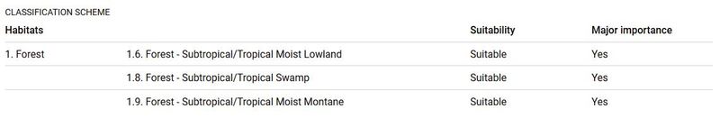
Habitat Classification Scheme codes are displayed, indicating which specific habitat types the taxon occurs in, including habitat suitability and whether it is of major importance to the taxon. For example:
- For plants and fungi, the growth form (tree, shrub, epiphyte, fungus, etc.) appears beneath the habitat classification scheme information.
Threats
 An essential part of a Red List assessment is knowing what threats are causing the taxon to decline. This information informs development of effective conservation actions and policies that address the activities that are pushing animals, plants and fungi towards extinction.
The Threats section includes the following information:
-
The general threats affecting the taxon are displayed (e.g., residential & commercial development, biological resource use, pollution, climate change & severe weather, etc.). Note that the general threat types have embedded hyperlinks; by clicking on threat, you will automatically search the Red List website for a list of all species that are coded as being affected by that general threat.
-
Below each general threat, more specific threats are listed (e.g., housing & urban areas, logging & wood harvesting, domestic & urban waste water, temperature extremes, etc.).
-
A description of what is currently known about the threats affecting the taxon, which often includes information on threatening activities and events, where in the taxon’s range the most serious threats are, and why the taxon is particularly susceptible to these activities.
-
Threats Classification Scheme codes are displayed, along with the following details:
-
The timing of the threat (i.e., ongoing; past (unlikely to return); past (likely to return); future; or unknown).
-
The stresses placed on the taxon (based on the Stresses Classification Scheme).
-
The scope of the threat (i.e., the threat affects the whole (>90%); majority (50-90%); minority (<50%); or an unknown proportion of the population).
-
The severity of the threat (i.e., causing very rapid declines; rapid declines; slow, significant declines; causing/could cause fluctuations; negligible declines; no decline; or unknown).
-
Use and Trade
 In all regions of the world, wild animals, plants and fungi are used for food, medicines, and other resources. Many assessments on The IUCN Red List record this information because is useful to highlight the importance of species to human health and livelihoods. Where exploitation is unsustainable, it is recorded in the Threats section to inform the extinction risk assessment.
The Use and Trade section includes the following information:
-
A description of use and trade of the species, including details of how it is used, which parts of the taxon are collected (entire individuals or parts of individuals), etc.
-
The end use of the taxon (food, medicine, pets/display, etc.) and whether the use is at local, national or international level. For example:
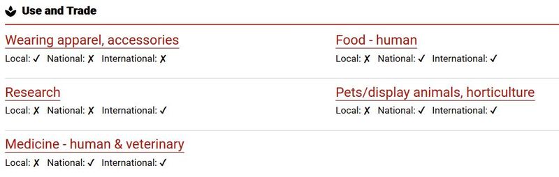
See the General Use and Trade Classification Scheme for the full list of end uses.
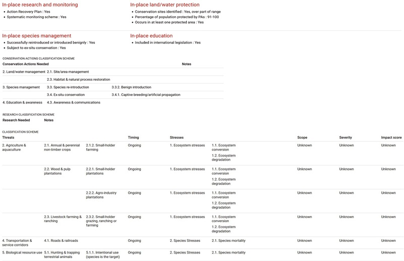
Conservation Actions
. Turtle egg incubation centre, Brazil. IUCN Photo Library / © Jim Thorsell.") The IUCN Red List recognises and applauds the many conservation activities that are currently underway around the world. It also highlights that for many taxa more conservation and research efforts are needed.
The IUCN Red List recognises and applauds the many conservation activities that are currently underway around the world. It also highlights that for many taxa more conservation and research efforts are needed.
The Conservation Actions section includes the following information:
-
The general conservation actions currently in place (e.g., research & monitoring, land/water protection, management, education, etc.).
-
Below each general conservation action in place, more specific conservation actions are listed (e.g., action recovery plan, occurs in at least one protected area, harvest management plan, included in international legislation, etc.).
-
A description of what is currently known about the conservation actions currently in place, and the recommended actions to help protect the taxon. Often this includes information on national and international legislation, current status on national Red Lists, occurrence in named protected areas, legislation that is or is not well enforced, education programmes, etc.
-
Conservation Actions Classification Scheme codes for recommended conservation actions for the taxon.
-
Research Needed Classification Scheme codes relevant to the taxon.
Bibliography
All references to published and unpublished material that are cited within the assessment text and general references used for the assessment are listed in the Bibliography section. The bibliography also includes the reference for the IUCN Red List in which the current assessment was published, and may include reference to past IUCN Red Lists in which historic assessments were publshed.
External Data
All of the fact sheets include links to external databases and websites, allowing users quick access to additional information about the species. Note that since these resources are all managed by other organisations, IUCN is not responsible for their content or accuracy. The PDF version of the assessment does not include external data.
The External Data section includes the following information:
-
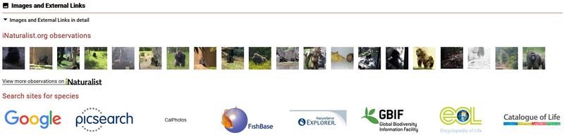
Links to search results for images of the taxon are provided, including links to iNaturalist, Google images, picsearch, etc. Links are also included to selected external sites for additional information about the taxon. For example:
-
Search results on the Species+ website for taxa listed in the CITES (Convention on International Trade in Endangered Species of Wild Fauna and Flora) Appendices are included, where you can find details of any international trade restrictions in place. By following the link to the Species+ website, you can search for species that are listed in the CMS (Convention on the Conservation of Migratory Species of Wild Animals) Appendices.
-
Search results for the taxon or related taxa on the Conservation Evidence website, where you can find evidence from the scientific literature about the effects of conservation interventions, such as methods of habitat or species management.
Corrected Assessments
 The IUCN Species Information Service (SIS) stores all published IUCN Red List assessments. Sometimes a published assessment must be modified to correct a mistake, or to add missing or new information that enhances the assessment, but is not enough to justify a full reassessment. Corrected assessments address these issues.
There are two types of corrected assessment:
-
Erratas: erratas are created when minor edits are needed to fix errors or add missing content to a published assessment. For example, replacing the distribution map with a corrected version (where the countries of occurrence in the assessment are not affected), or correcting a mistake in an Assessor’s name.
-
Amended Assessments: when more substantial edits are needed, an amended assessment is created. These edits usually result in a change to the search results on the website, which might affect the summary statistics and any analyses of the Red List data. For example, replacing the distribution map with a corrected version (where the countries of occurrence in the assessment are affected), or correcting a threat code. An amended assessment may also modify the assessment citation (e.g., changing the order of Assessor names or adding a name that was missing previously).
Fact sheets for corrected assessments include the following information:
-
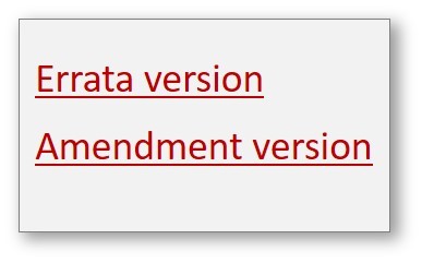
The type of corrected assessment (errata version or amended version) is displayed at the top of the assessment page, beneath the download option.
-
The correction type includes a hyperlink to a section that explains what edits have been made to the assessment.
-
A new, corrected version of the assessment PDF is attached.
-
For errata assessments, the previous (uncorrected) assessment is not included in the Red List Assessment History section. If you require a copy of the original published assessment, please contact the IUCN Red List Unit.
-
For amended assessments, the previous (uncorrected) assessment is included in the Red List Assessment History section, with a hyperlink to the original published assessment.
-
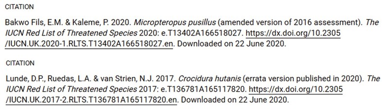
The assessment citation highlights the assessment as a corrected version. For example:
-
Note that amended assessments use a new publication date in the citation, while errata assessments use the original publication date.
Supplementary Information
 Some assessments on the Red List website include Supplementary Information. These documents contain images, figures and tables that cannot be included within the assessment itself. Often, they include data and models used to calculate parameters for the Red List assessment.
Supplementary Information is available from the Download button at the top of the fact sheet, and from hyperlinks from the relevant sections.
Taxonomic Revisions on the Red List
Taxonomy is in a constant state of change. Along with new taxa being added, existing taxa on The IUCN Red List regularly undergo taxonomic revision. Sometimes this results in a taxon being split into two or more taxa, or taxa being merged together to form one taxon. Sometimes a species will be assigned to a different genus, a subspecies will become a species, a species will become a subspecies, or an error in the taxon’s name will be corrected; all of these changes result in the scientific name changing. This may happen at any time, with or without the taxon being reassessed on The IUCN Red List.
If the scientific name changes without a reassessment being published, then the name attached to the fact sheet no longer matches the name used in the assessment citation or the name used in the PDF version of the assessment. For transparency in these cases, the fact sheet includes a note of the name used when the assessment was first published. For example:
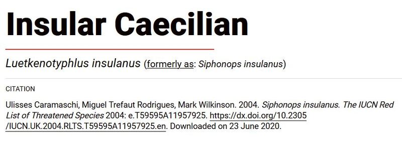
The hyperlink embedded in the text "formerly as" opens the Taxonomy section where the taxonomic change reason is displayed. Note that the taxonomic source is also updated to reflect current source followed for the change.